
Costain, VINCI Construction Grands Projets and Bachy Soletanche JV
Innovation in Instrumentation & Monitoring
About this entry
Entry Title
Thames Tideway East – Monitoring Using LIDAR During Dredging Operations
Long Description of Entry
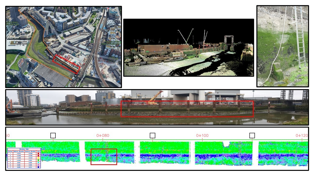
At the Tideway East Greenwich tunnel drive site, the ‘More by River’ strategy aims to utilise barges on Deptford Creek to deliver tunnel segments and remove tunnel spoil, thus reducing lorry movements through the heavily-congested Greenwich area. To facilitate this, a three-week dredging campaign was required. In order to eliminate the requirement to physically attach equipment to the river walls and therefore reduce the access and consents challenges, it was decided to monitor the river walls using LIDAR was the obvious solution as the project already owned the equipment & software and this would remove the need for installations. This resulted in a saving to the project of approximately £200k. A trial was carried out on two sections of wall to prove the repeatability and accuracy that could be achieved. A Leica P40 scanner was used to capture the LIDAR data. Initially the accuracy did not meet the specified tolerance, as the scan target geometry was restricted by access issues. An alternate solution using only the surrounding structures outside the zone of influence as a control scan resolved this issue allowing ‘Scan to Scan’ registration. The scan data was registered using Leicas’ Cyclone software. Once registered, the latest scan data on each river wall was edited to remove all data apart from the river wall and decimated to a 50mm point spacing. The data was then exported to a PTS type data file. The PTS XYZ data was transformed to Chainage/Height/Offset with a separate alignment for each wall. Base surfaces were created for the river walls pre-dredge and all subsequent surveys were then compared back to those. This was carried out using Autodesk Civil3D. A coloured heatmap was created to show the deviations in the monitoring survey compared to the base pre-dredge survey. Increments of 3mm would visually highlight areas of movements. A low percentage of noise could easily be discarded visually. Using the survey methodology described, CVB were able to achieve repeatable measurements to
About this category
About
This category recognises innovation and excellence in site surveying and monitoring on tunnelling projects. Entrants to this category must demonstrate and provide evidence to show how, on a specific tunnelling and/or underground project, innovative use of existing instrumentation and monitoring techniques or pioneering new technology is contributing to an improved outcome for the project team and/or client.